 |
||||||||||||||||
Remote Sensing, Photogrammetry & Imaging GIS
Our staff has extensive experience in dealing with the intricacies of
Remote Sensing and photogrammetric applications.
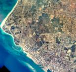
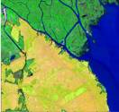
IDAS has recently completed Remote Sensing-related projects for the South Florida Water Management District (Georeferencing and Resolution Merge of IRS and SPOT images), and for the Island of Aruba (Georeferencing and Compression of Aerial Images Covering the Entire Island of Aruba). Our specialists have also conducted training courses in ERDAS Imagine and Image Analysis software for the Government of El Salvador, in Central America.
Our company provides such comprehensive services with a complete set of state-of-art software from ERDAS, the world’s leading Remote Sensing software company:
-
ERDAS IMAGINE
-
Image Analysis
-
OrthoBASE
-
Stereo Analyst
IDAS
We can help you through the entire process of bringing remotely sensed data to any of your projects, from importing and preparing the data, to processing and analyzing it.
IDAS can provide data from the leading remote sensing data producers, such as Space Imaging, so we can also advise you about the best data to use according to your needs.
Integrated GeoSpatial Technology Solutions

3134 Coral Way, Suite B, Miami, FL 33145
Tel: (305) 665-8303 Fax: (786) 552-6359 - E-mail:info@idasnet.com