NEWS & EVENTS

Geo-Spatial Technology | GIS | GPS | ArcGIS | Content Management
If you want to know about some used terms of the field, click on the above menu


1. GIS Mapping: Great help for San Diego firefighters
2. GeoPad: New tool for field education
3. New ESRI partner gives more resources to GIS professionals
4. GIScience 2004 - Conference on GIS
5. Future Release from ESRI
6. Lizardtech acquired by Celartem
7. ArcWeb has New Data Sources
8. New LPS from Leica


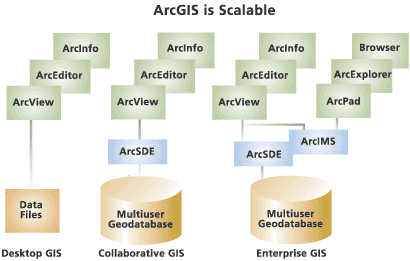
ArcGIS Software

ArcGIS is a scalable system of software for geographic data for every organization--from an individual to a globally distributed network of people.

ArcGIS is a family of software products that form a complete GIS built on industry standards that provide exceptional, yet easy to use, capabilities right out of the box. ArcGIS is a complete, single, integrated system for geographic data creation, management, integration, and analysis.
Much more than a specialized offering for a small niche of specialists, ArcGIS is designed as a scalable system that can be deployed in every organization, from an individual desktop to a globally distributed network of people.

Excerpted from Introduction to ArcGIS in www.esri.com Copyright © 1995-2003 ESRI

  1. Happy New Year!
2. Course schedule for New Year 
3. We are giving a new look to our site
 
 
Geo-Spatial Technology | GIS | GPS | ArcGIS | Content Management


Click here to link to our Barbados-based Affiliate
Home | About Us | Products | Services | Training | News & Events | Gallery | Contact Us
Copyright © IDAS 2003-2004, All Rights Reserved
3134 Coral Way, Suite B, Miami, FL 33145
Tel: (305) 665-8303 Fax: (786) 552-6359 - E-mail:info@idasnet.com