 |
||||||||||||||||
At Space Imaging, we’re passionate about supplying Earth information derived from space imagery and aerial photography. It’s our job to meticulously document the ever-changing features of our environment, our resources, and our world.
Space Imaging's imagery product suite consists of satellite data derived from the IKONOS, IRS, and LANDSAT 7 sensors, as well as aerial data from DAIS (Digital Airborne Imaging System) and Kodak's extensive archive of high-resolution urban imagery. This suite of products was designed to meet the full spectrum of customer requirements with a complete range of resolution and spectral options.
Radiometrically and geometrically
correct high-resolution imagery
 Space
Imaging uses the power of the IKONOS satellite to create Geo 1m
and 4m - a product that defines the future of high-resolution imagery.
Space
Imaging uses the power of the IKONOS satellite to create Geo 1m
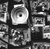
and 4m - a product that defines the future of high-resolution imagery.Panchromatic images are radiometrically corrected, geometrically corrected, and map projected with a 1-meter map increment. Panchromatic images are available in easy-to-use, wide-dynamic range 11-bit formats. Geo is also available in 4-meter multispectral format as well.
This is a high-resolution, low cost, quick look product suitable for emergency response, intelligence interpretation, and site monitoring.
Radiometrically and geometrically
correct high-resolution imagery
 Space
Imaging uses the power of the IKONOS satellite to create Precision 1m and
4m a product that defines the future of high-resolution imagery.
Space
Imaging uses the power of the IKONOS satellite to create Precision 1m and
4m a product that defines the future of high-resolution imagery.
Space Imaging designed for provincial, state and local governments that require timely, highly accurate, orthoimagery.
This is a high-resolution, accurate imagery is suitable for applications ranging from base mapping, map revision, and GIS update to planning, site selection and development.
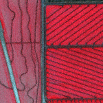
DEMs Digital Elevation Model
Two-meter, three-meter and five-meter vertical accuracy DEMs are available for California (San Francisco Bay Area, Sacramento, Los Angeles Basin, San Diego, and large sections of the Central Valley), Denver, parts of Venezuela, the Panama Canal, London, and Germany. Additionally, large regions of Indonesia are available, including Java, Irian Jaya and regions of Jayawijaya.
DEM data is one of the most important data layers in a GIS, and forms the topographic base map for most GIS modeling. It is the foundation for hydrologic modeling projects, determining site suitability, engineering planning and design, slope stability and much more.
CARTERRA ANALYST
Industry's Best Tools - Working Together as a Powerful Solution!
Difficulties in assessing urban growth, aging infrastructure, watershed management, traffic congestion, and declining natural resources can pose a challenging situation for planners and engineers.
Additionaly, customers may face issues concerning handling large amounts of data, establishing a system that can keep up with today's technology, and enhancing the bottom line by increasing productivity and reducing costs. Establishing and managing information in a Geographic Information System (GIS) can be a large and daunting task, and rquires continuous maintenance.
CARTERRA Analyst can provide a cost-effective way to increase productivity for those with Geographic Information Systems or those looking to establish one.
CARTERRA Analyst integrates Geographic Information Systems, remote sensing, imagery analysis, photogrammetry and cartography tools into a single workstation enabling the user to:
- Search, browse and retrieve images and data from a database
- Perform multispectral analysis
- Create and combine vector and raster files
- Generate reports and products
- Establish
GIS databases of reports, data layers and images
CARTERRA
Analyst incorporates industry-leading tools, such as ESRI ArcView,
ERDAS Imagine, Sensor Systems RemoteView, Netscape Navigator, Core TerraSoar,
GDE SocetSet, Applix Graphics and Microsoft Office.
5-Meter Data You Can Fly-Through!
The CARTERRA 3D DOQ product allows you to visualize imager ythe way you view the world - in three dimensions. And since this interactive 3D flythrough application runs on a PC using 5-meter digital orthorectfied imagery in USGS quadsheet configurations, it's easy-to-use and cost-effective.
Simple, intuitive controls allow you to fly anywhere in the image, visualizing transportation infrastructure, mountains,valleys, watersheds, and other natural and cultural features.
CARTERRA 3D DOQ is self-loading - just insert your CD-ROM into your computer and you're flying! No other product in the world offers you these features at such a low cost. The software provided is able to view special Space Imaging data formats.
3134 Coral Way, Suite B, Miami, FL 33145
Tel: (305) 665-8303 Fax: (786) 552-6359 - E-mail:info@idasnet.com